Topographic map Study guides, Class notes & Summaries
Looking for the best study guides, study notes and summaries about Topographic map? On this page you'll find 216 study documents about Topographic map.
Popular textbooks 'Topographic map'
All 216 results
Sort by
 Popular
-
Michigan residential builders maintenance and alterations 5 practice exam with 100% correct answerss
- Exam (elaborations) • 8 pages • 2024
- $13.99
- 1x sold
- + learn more
SITEWORK, FOOTING, AND FONDATIONS FIRST SECTION A foundation drain shall extend past the outside edge of the footing at least how far? 12 inches What are batter boards? Stakes and ledger boards marking building lines. What is the purpose of a cove or can't strip at a foundation joint? Deflect water from the foundation wall. What is the MINIMUM overlap for the joints in the polyethylene film moisture barrier applied over the exterior of a below grade foundation wal...
 Popular
-
Residential Contractor Practice Exam 2023 Questions and Answers
- Exam (elaborations) • 3 pages • 2023 Popular
- $9.99
- 1x sold
- + learn more

-
Graded Assignment | Lab Report | Topographic Maps
- Exam (elaborations) • 3 pages • 2023
- $5.49
- 2x sold
- + learn more
Graded Assignment Lap Report: Topographic Maps Answer the questions. When you are finished, submit this assignment to your teacher by the due date for full credit. Total score: ____ of 35 points Map and Profile (Score for Question 1: ___ of 14 points) 1. Draw your topographic map in the space below. Include the name of the island, scale, legend, compass direction, vertical units and contour interval on your map. If you need more room, you can use a full sheet of pap
-
Tactical Tools (Corporal's Course) questions and answers 2023
- Exam (elaborations) • 39 pages • 2023
- $30.49
- 3x sold
- + learn more
A map is defined as a graphic representation of a portion of the Earth's surface drawn to scale, as seen from above. It uses colors, symbols, and labels to represent features found on the ground. -The ideal representation would be realized if every feature of the area being mapped could be shown in true shape. -The purpose of a map is to provide information on the existence, location, and distance between ground features, such as populated places and routes of travel and communication. I...

-
Topographic Maps Exam Questions with Correct Answers
- Exam (elaborations) • 3 pages • 2023
- $12.99
- + learn more
Topographic Maps Exam Questions with Correct Answers Topographic Map - Answer-shows the surface features, or topography of Earth or a certain area. What does a topographic map show? - Answer-it shows natural features such as rivers and lakes. They also show some features made by people such as brodges. They also show elevation. Elevation - Answer-The height of an object above the surface of the sea. What is the elevation at sea level? - Answer-The elevation at sea level is zero mete...

As you read this, a fellow student has made another $4.70


-
Topographic Map Exam Questions with Correct Answers
- Exam (elaborations) • 2 pages • 2023
- $12.49
- + learn more
Topographic Map Exam Questions with Correct Answers On a topographic map, the difference in elevation between two side-by-side contour lines is called the ___ A. contour interval B. index contour C. depression contour D. hachure - Answer-A. contour interval A point of known elevation on a topographic map is called a/an A. hachure B. contour interval C. topographic profile D. elevation - Answer-C. topographic profile The vertical distance between a given point and the datum plane ...
-
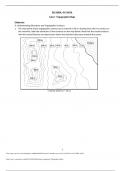
Sketching Assignment - Topographic Maps - Already Graded A+
- Exam (elaborations) • 6 pages • 2023
- $9.99
- + learn more
ESC1000L, GLY1010L Lab 2: Topographic Maps Elaborate A: Understanding Elevations and Topographic Contours 1. The map below shows topographic contours at an interval of 20 m. Starting from the 0 m contour at the shoreline, label the elevations of the contours on the map below. Note that the closed contours with the inward hatches are depressions where the elevation decreases towards the center.

-
Topographic Maps Test Questions with Correct Answers
- Exam (elaborations) • 2 pages • 2023
- $11.49
- + learn more
Topographic Maps Test Questions with Correct Answers Mapmakers use contour lines to represent what three things on topographic maps? - Answer-elevation, relief, and slope contour line - Answer-A contour line on a topographic map connects points of equal elevation. contour interval - Answer-The change in elevation from contour line to contour line is called the contour interval. index contours - Answer-Every fifth line, known as the index contour, is darker and heavier than the other...

-
Topographic Maps Exam Questions with Correct Answers
- Exam (elaborations) • 3 pages • 2024
- $7.69
- + learn more
Topographic Maps Exam Questions with Correct Answers Topographic Map - Answer-shows the surface features, or topography of Earth or a certain area. What does a topographic map show? - Answer-it shows natural features such as rivers and lakes. They also show some features made by people such as brodges. They also show elevation. Elevation - Answer-The height of an object above the surface of the sea. What is the elevation at sea level? - Answer-The elevation at sea level is zero meters...

-
Geology Lab Exam II Questions and Answers 2024 with Complete Solution.
- Exam (elaborations) • 15 pages • 2024
- $13.49
- + learn more
Geology Lab Exam II Questions and Answers 2024 with Complete Solution. A topographic map has a ratio scale of 1:250,000. One centimeter on the map equals _____ kilometers in the real world. 2.5 Assuming a contour interval of 50 feet, what is the elevation of the centermost contour line in this figure? Please observe that the first contour line has an elevation of 100 feet above sea level. 300 feet Use the Public Land Survey System to locate the X out to three quarters. Assume that it is...
